
|
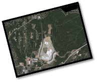
The landscape as we know it is continually changing, impacting both present and future generations. This is not only important for future planning of the human infrastructure, but also for the conservation and preservation of our natural surroundings. Hence, land use/land cover studies provide valuable information for large-scale vegetation biomass and green infrastructure assessments that are key components when determining the best plan of action for conservation policies or urban planning. Most green infrastructure assessments use GIS as a modeling and visualization tool; and by using data such as land cover (e.g., wetlands, roads streams, etc.), sensitive species, soils, elevation, and development pressure, we can identify a network of areas (i.e., hubs and corridors) that contain the most ecologically critical lands that remain on the landscape. By connecting the areas (hubs) of interest through a series of corridors (greenways or blueways) that include rivers and streams, parks and forests, and protected and unprotected lands, we can better manage and plan the use of our environmental and economic resources. These GIS techniques are being utilized to develop a pilot model within the City of Chattanooga in an area where sensitive species occur and rapid development is taking place. The goal of the project is to take the results generated from the pilot study, and to apply the same strategies and techniques at a city wide or regional scale in order to promote more strategic conservation and smart growth.
|
|
Study Species / Study Area |
|
Home |
|
Objectives |
|
Preliminary Findings |
|
Conservation Implications |
|
Contact Us |
|
Acknowledgements |

|
Frequently Asked Questions
· What is Greeninfrastructure or Greenprinting? It is a series of well designed plans that integrate and connect managed lands, working landscapes and other green spaces that conserve and promote ecosystem services while providing associated benefits to human populations. · How are hubs defined? Hubs can be defined as any core area that is important to our natural heritage. These hubs may also network and incorporate surrounding landscapes in the form of conservation or predictive buffers. Also, hubs can serve as necessary sink and source populations. · What makes for a good corridor? A good corridor is one that promotes the free movement of animals from one hub to the next and simultaneously encourages gene flow. Corridors, however, are not designed to be suitable habitat, they merely have enough usable habitat to allow for the free passage between and among hubs. · How does scope, extant and scale influence your project? Most greeninfrastructure projects occur at a coarse scale; however, foundational components can be found at all scales, from state-wide, to the county, city, and fine scale. Critical elements of the implementation strategy, such as low-impact development practices, conservation developments, green/grey interface, blue space/ways, are necessary variables to any greeninfrastructure project, and are often found in the details of fine scale data.
For further reading on the primary reason for this project please click here. |
|
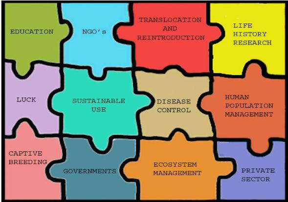
The Conservation Puzzle |
|
The components of green infrastructure planning has integral parts that go together like a puzzle.
Designed by Stefan Moss |